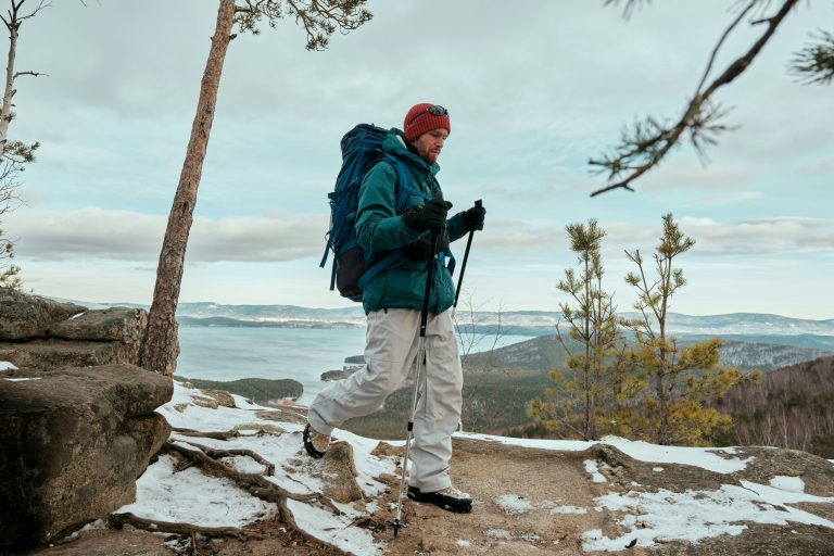
To visit Karina Trolii was our big dream. We decided to go on this trip on our own by renting a motorhome. We set off on the tour in the second half of August. Our main assumption was to move to a new place every day combined with sightseeing and overnight in the wild or at campsites. In order to facilitate your stay on the spot, even before departure I prepared a preliminary plan where we will go and what we will want to see.
Remember that due to the topography of the south-west coast of Norway, it is necessary to plan a smaller number of kilometers to cover every day. Some fragments must be overcome by ferries. However, if you want to bypass the ferry, you have to drive, and the speed limit is the allowed speed on Norwegian roads in undeveloped areas, which is 80 km/h (90-100 km/h on motorways and expressways). And in Norway, I would rather recommend following the rules, because a mandate can cost us a lot ;- )
At the beginning of planning our trip, I assumed that I would use ferries, treating them also as an attraction and experience.
Day 1 – cruise to Sweden
The first thing to do is to set a route to Norway and return. We decided to go to the German Rostock and from here by ferry StenaLina go to Trelleborg in Sweden (ferry connections StenaLine https://www.stenaline.pl/linie-promowe/rostock-trelleborg). The cruise takes about 7 hours, there are 3 within the house, we chose the night.
Day 2 – on the way to Norway
We arrive at the port in Sweden in the early morning hours. Our goal after leaving the ferry is to reach the Atlantic Road in Kristiansund as soon as possible, which is the northernmost place of our departure. Then we want to get south towards Stavanger.
One of the places where we stayed was the Tjörnbron Bridge (parking at Tjörnbro Park). The tragic story of 1980 is connected with it. – the MS Star Clipper suddenly drifted off course and hit the bridge that was then called Almöbron. Unfortunately, it was not possible to quickly stop traffic from one side of the road, as a result of which several cars fell into the water, and several people died. The bridge was rebuilt with a new name. The cause of the accident could not be determined.
Route: 520km
Parking 1: parking “Susedalen Östra” (Sweden)
Parking 2: parking at Tjörnbro Park (Norway)
Day 3 – Tusenfryd amusement park
On the third day of our trip we decided to spend not on sightseeing but on entertainment and we went to the amusement park Tusenfryd : ) TusenFryd, is a park where you will find everything: rollercoasters, swimming pool, Viking park, water slides and many other attractions. TusenFryd Amusement Park is 20 km from Oslo – the capital of Norway. Here you can find the most important information: https://www.tusenfryd.no/
Route: 230km
On the way: Tusenfryd amusement park
Day 4 – Route to the North
The fourth day is mainly a ride to the next place on our map. Along the way, you will pass many interesting and beautiful places such as Lillehamer with its famous ski jump, the Rondáň National Park and many lookout points. Rondane is Norway’s oldest national park, the region is so beautiful that you don’t want to leave.
Route: 350km
Along the way: the ski jump in Lillehamer, the Rondáne National Park, viewing points, e.g. Sohlbergplassen
Day 5 – Innerdalen Valley
This time, we spend the second night in the same place and the next day we go for a walk to the picturesque Innerdalen valley, called the most beautiful mountain valley of Norway. It is worth having a waffle in the hostel – they are the tastiest in the world!
Route to the parking lot to the Innnerdalen Valley: 20km
Walk: 3,5km one way
Hostel in Innerdalen: Renndølsetra
Day 6 – Atlantic Route
On the 6th day we reach the northernmost point of our trip – the Atlantic Road. We start from the tunnel under the Atlantic from Kristiansund to Averoy – it is one of the deepest undersea tunnels in the world (250m deep). You must pay a fee before entering.
We are approaching the famous Atlantic Route. It was for her that we wanted to come to Norway. It is a 9-kilometer section of road No.64. It runs through seven bridges that rise above the sea and connect small islands. We stop at all the car parks we meet, from some start mini-walking routes, BEAUTIFUL !!! views
The Atlantic road runs along Hustadvika Bay, going further west, we normally stop at almost every parking place to admire the views.
In the town of Bud we stop to see Fort Ergan, built by the Germans during the Second World War. There is now a museum. From the hill you can admire the surroundings.
Route: 220km
Along the way: Tunnel under the Atlantic, Atlantic Route, Fort Ergan
Accommodation: Camping Romsdalseggen
Day 7 – The Trolla Road and the Geirangerfjorden Fjord
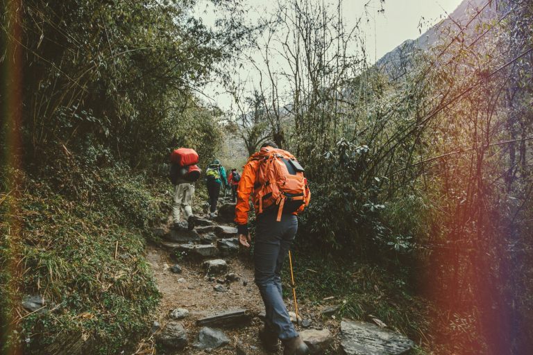
Trolla road (Trollstigen) to one of the most famous attractions and scenic paths. It has 11 sharp bends and makes a huge impression live. When we were driving up the mountain almost all the way we were accompanied by clouds and nothing could be seen. Fortunately, a reward awaited us at the top – a vantage point from which you can admire the whole Trolla Way and the valley.
Going further, about 15km before the ferry crossing in Valldal, we stopped at the Gudbrandsjuvet gorge. This place did not make any greater impression on us.
On the shores of the Geirangerfjorden fjord, we turn down the Eagles’ Road to the village of Geiranger. I recommend stopping at the Ørnesvingen viewpoint, from which you can admire the fjord. And remember about the obligatory photo with the Troll: )
About 15km further we stop by the Djupvatnet lake to take some pictures. We can go here to the Dalsnibba viewpoint, we went on our way…
Route: 210km
Along the way: Trolla Road, Gudbrandsjuvet Gorge, Eagle Road, Geiranger, Lake Djupvatnet
Day 8 – Briksdal Glacier
The main attraction on that day was the Briksdal Glacier. You will get there from Olden heading south, the road ends with a parking lot. If you are tired, you can drive up the first stretch from the parking lot by electric electric cars. Later, unfortunately, you have to walk to reach the glacier.
Route: 180km
On the way: Briksdal Glacier
Day 9 – Fjords cruise
On the 9th day of our trip we went on a ferry cruise from Kaupanger to Gudvangen. It passes through three fjords: Nærøyfjord, Aurlandsfjord and Sognefjord. The views were amazing and even bad weather, which unfortunately accompanied us was not able to spoil our trip!
The cruise lasts 2,5 hours, tickets can be booked in advance.
After the cruise, we are looking for a place for a campsite to relax after a whole day, especially as it was raining and it was cold. We dreamed of hiding under a warm quilt ;- )
Route: 120km, if without a ferry tour
On the way: the Kaupanger-Gudvangen ferry
Day 10 – Voringsfossen Waterfall
The next day we went to see one of the most famous waterfalls in Norway, Voringsfossen, with a height of 145m. There is a car park by the road, from which you can get to the lookout point. If you feel like it, I recommend you drive above the waterfall, towards the Fossil Hotel.
Route: 214km
Along the way: Voringsfossen waterfall
Day 11 – Røldal
Our next stop is the village of Røldal, where we visit the stave church – it is a type of wooden church, on which corner pillars are placed long boards forming a wall. Sometimes evening concerts are held in the church.
After visiting the church, we went to the nearby most important attractions of Norway – Preikestolen.
Route: 170km
Along the way: Røldal church
Day 12 – Preikestolen and fjord Lysefjorden
Preikestolen (also called Pulpit Rock) or the most famous rock shelf. It is probably Norway’s most famous cliff, with a height of 604 m. It offers an amazing view of the Lysefjorden fjord. Some also sleep nearby in tents to see the fjord at dawn.
Unfortunately, that day we met an unpleasant surprise on the spot… Due to the cloud cover and rain, after reaching the place we saw only foggy silhouettes of other tourists. I will add that there are so many tourists here that if you do not arrive early in the morning, you will literally be walking in the people’s string. Which is neither pleasant nor safe. The time to get from the car park to Preikestolen takes about 2h in one direction, depending of course on our condition and the number of other tourists.
In the afternoon we move towards the coast.
Route: 140km
On the way: Preikestolen
Day 13 – Norwegian beaches
We decided to spend the penultimate day of our trip by the sea in Olberg.
Although the weather was not suitable for sunbathing, it was nice to walk and sit on the beach or between the dunes despite the cold weather. I encourage everyone who goes to Norway to spend at least one day resting on the coast! Invaluable experience…
Route: 50km
Accommodation: Camping Olberg
Day 14 – return to Denmark
On the last day, on our way to the port on the ferry, we went to Stavanger to take a walk and eat something. We also planned shopping, but unfortunately it was Sunday and all stores in Norway were closed. Fortunately, we managed to find only one small shop that was open.
And so we went to the port to our ferry to Denmark…
Timetable of Stavanger ferries – Hirtshals: https://www.directferries.se/
Beautiful Norway to see you soon
After sailing by ferry to Denmark, we headed for home. On the way back we stopped near Belin for one night.
How many kilometers did we travel on this journey?
The route described above, i.e. from the ferry to the ferry, is about 2450 km.
As you can see below, almost the second time it took us to get to Germany, and to return from Denmark.